
The Mystery of Roblar de la Miseria
And the treasure of California's land grant diseños
 by Joe Honton
California place names often bear witness to the state's pre-Gold Rush history, when California was a Mexican territory.
California Place Names has been the standard reference work for anyone interested in this topic since its compilation in 1949 by Erwin Gudde. But some of the state's more puzzling names receive no mention in that book.
Oftentimes we can attribute place names to a significant historical event, or a leader who played an important role in the development of a region. Other times, place names are purely descriptive.
But that leaves us with a mystery when it comes to Roblar de la Miseria, a sparsely populated area of Northern California, notable for is cattle ranches and golden hills. How do we account for such a miserable name?
A weak translation of the Spanish term would be oak of the misery
, while a more nuanced translation might be oaks of misfortune
.
A visitor today would find a place of splendor, with round-topped hills covered in wild oats, burr clover, and stork's-bill filaree. Visitors come from afar for a few moments of bliss as they drive through the area's broad valleys to see free-range cattle grazing in the open landscape.
So what gives? Is this one of those cases where a misleading name was applied in order to intentionally hide its charm? Another Greenland/Iceland subterfuge?
To trace this unique name to its origins we need to look no further than the California land grants.
Originally, land was granted to individuals for the purpose of cattle ranching by the Viceroy of New Spain, under the authority vested in him by the king. These grants were somewhat akin to today's livestock grazing permits: the land was still owned by the natives, but so long as the ranchers didn't disturb the native population they were permitted to use the land for cattle.
Only 23 of these grants were made during the Spanish period of Alta California from 1769 to 1821.
When the Spanish empire disintegrated, California as we know it today fell under the authority of a series of reigning bodies with each in turn gaining permission to grant leases and titles.
- The Mexican Empire era (1821-1823) was short-reigned: Emperor Agustín de Iturbide did not issue any land grants.
- The First Mexican Republic era (1824-1835) had five California governors who issued a total of 61 land grants.
- The Centralist Republic of Mexico era (1835-1846) had eight Alta California governors who issued a total of 404 land grants.
During that final chapter of Mexico's tumultuous rule, the hasty land grab by ranchers and early settlers was driven by the promulgation of new rules which turned what formerly were simple leases into patented titles to the land.
At the conclusion of the Mexican-American War (1846-1848), the Treaty of Guadalupe Hidalgo guaranteed that any lands granted to citizens during the Spanish and Mexican eras would be honored if their claims could be substantiated. To do this, grantees brought forth their original application documents. These were often were accompanied by diseños — unsurveyed maps of their claim, showing prominent features and approximate boundaries.
These diseños are treasures of California history. Historical ecologists study them for clues to the true nature of the area.
All of the diseños are in Spanish, so there are interpretation challenges for non-native speakers. Still, Spanish topographical terms are a common part of the American West's geography. Most modern day residents implicitly get the gist of their meaning.
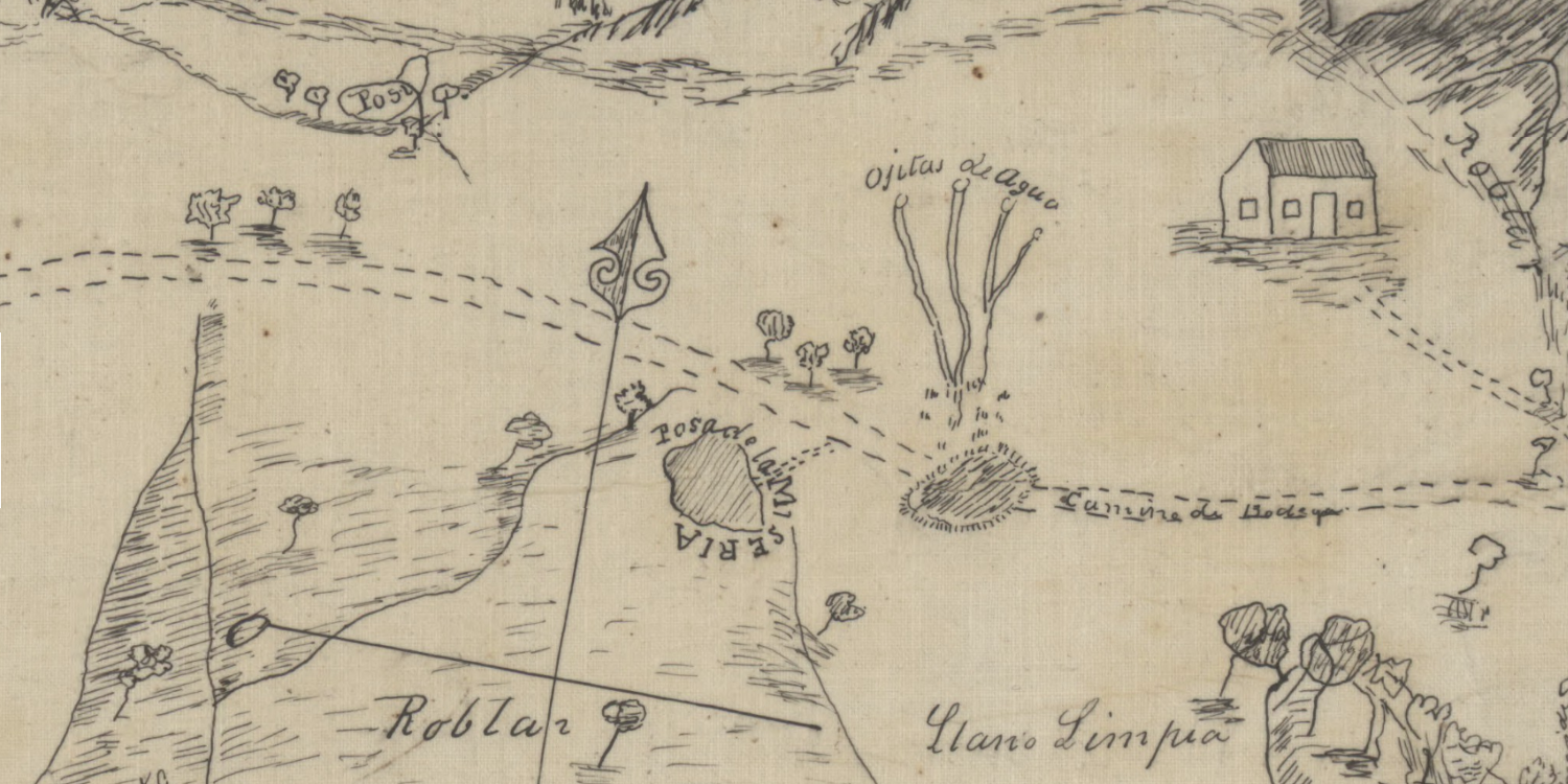
But some 19th century terms are perplexing. The term posa is one of those, as it is not in any dictionary. But getting to the root of its meaning is central to solving the mystery of the Roblar.
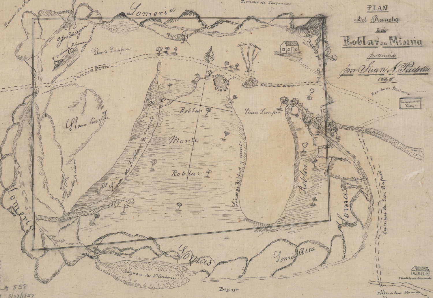
An examination of the diseño of Roblar de la Miseria, plainly reveals Juan Padilla's claim. It's a large tract of land that is situated in today's Sonoma County. The sketch shows all of the prominent features of his claim in detail:
- lomeria — range of hills
- loma alta — a high hill
- las dos piedras — two rocks, a prominent landmark
- 2 piedras blancas — two white rocks
- roblar monte — an oak-studded highland
- llano limpia — a clean plain
- ojos de agua — natural springs
- ojitas de agua — tiny springs
- estero — an estuary
- arroyo — a dry creek
- laguna — a lake with a blocked outlet
- posa
The word posa is used six times on the sketch: at the base of hills, at the head of a dry creek, and once very prominently along the road from San Rafael to Bodega. This last one is the key feature that helps to solve the mystery of the Roblar. It is labeled Posa de la Miseria.
On this map it seems that posa is used as a term for a stagnant body of water. So the map's prominent feature might be translated as bad waters of destitution
or more colloquially as the wretched watering hole
. Fair warning to travelers to refresh their mounts elsewhere.
Today's traveler can still follow the original route of the Camino de Bodega by driving along what has since been renamed as Roblar Road. And for refreshment they can stop at the Washoe House, built in 1859 as a stagecoach stopover where the road from San Rafael forks towards Santa Rosa to the north, and Bodega to the west. The Washoe House still serves up hot meals to roadside travelers in the daytime, and brewed beverages to locals in the evenings.
The land grant diseños are a unique and valuable treasure of California history. They are the original source documents that were used by the U.S. District Courts of California to adjudicate land claims made by pre-Gold Rush colonists under the terms of the Treaty of Guadalupe Hidalgo.
They are held in public trust by the University of California's Bancroft Library. They can be examined online through the Calisphere archives.


